Welcome to The Victorian Maps of Devon.
In 2000 Francis Bennett and myself published our second book on the maps of Devon and listed all known maps printed between 1838 and 1901 showing the whole of the county of Devon on either one or two sheets. Although we omitted Ordnance Survey sheets and atlas maps on a sheet basis, we were still able to list 70 different maps along with their sources and provide informIation on the people behind them.
This site is the internet version of the revised Second Edition of The Victorian Maps of Devon.
Since the original work was published more maps have come to light and new information discovered, furthermore, as the authors are no longer restricted to the A4 format, we have been able to include extra information on many of these issues.
Interested users of this site are invited to contribute new information and new states or even new maps. Moreover, in the course of our researches we may have omitted something, overlooked a source or falsely interpreted our notes. We apologise for any errors and welcome correspondence and corrections from fellow enthusiasts and collectors.
The Printed Maps of Devon – covering maps from 1575-1837 is already on-line.
Kit Batten
Auction News 2025
OCTOBER 2025
A RARE MAP BY BENJAMIN DONN AT AUCTION
Benjamin Donn´s A Map of the County of Devon is quite well known and can be found on this website at entry 44 (12 sheet map) and 45 (the accompanying index map).
However, his map of the Western Circuit of England is less well known and significantly rarer.
This map covers Cornwall, Devon, Dorset, Wilts & Hants and measures 830 x 1340 mm. Dedicated to the Earl of Salisbury (and others) it includes inset maps of Plymouth and Portsmouth harbours and the Scillies. A copy came up for auction recently and the hammer went down at 2000 pounds. It is probably on sale at a London dealer´s for double!!
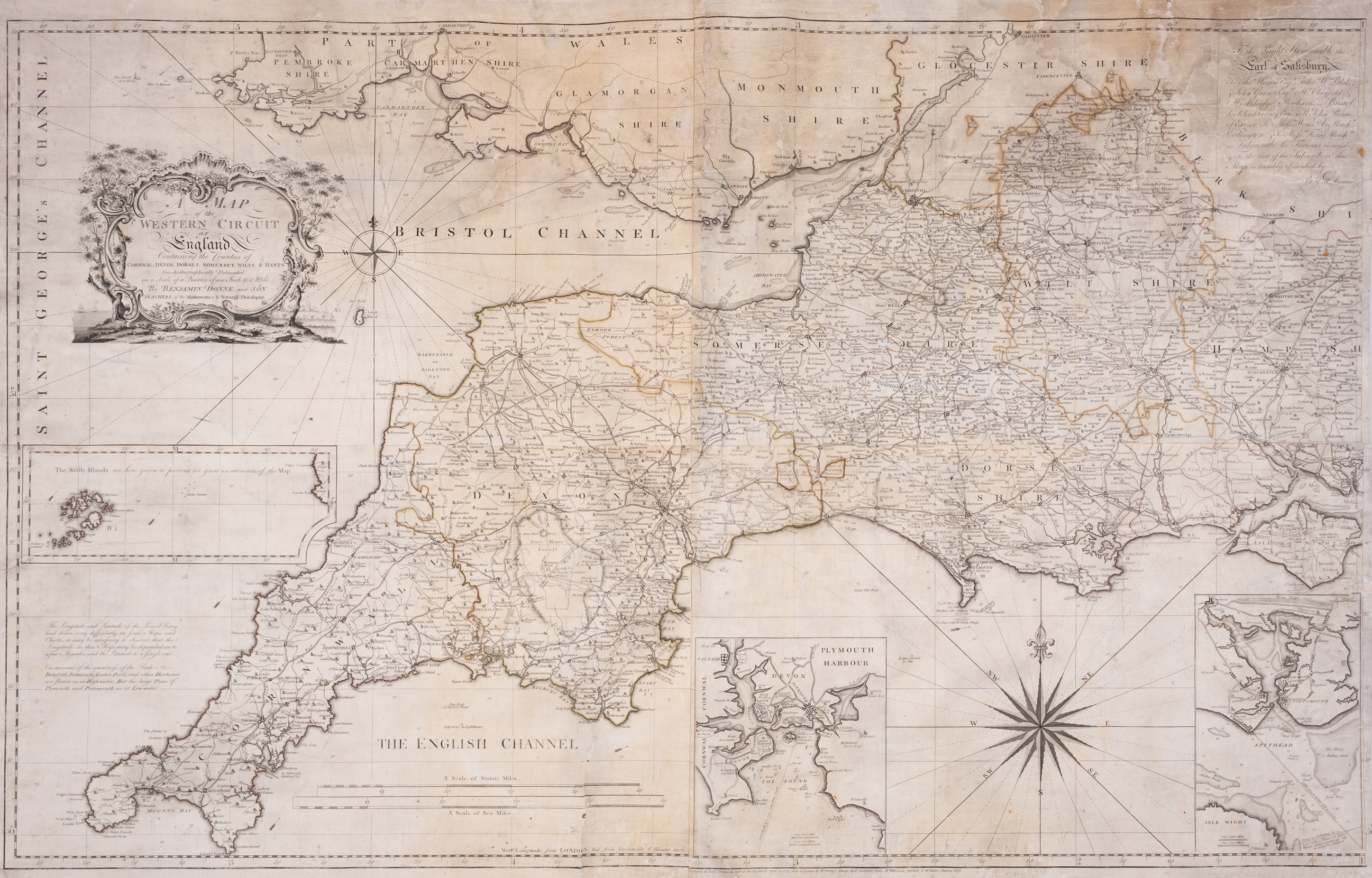
Image copyright Forum Auctions, London. Another copy is held at the British Library (Shelfmark: Maps K.Top.6.66.2.TAB) which can be accessed online).
Contact KitTheMap@aol.com if you wish to contact me directly!
I would really enjoy hearing from other collectors.
Kit's Blogs
Just a few of my blogspot on cartographic topics:
Constantly being revised:
Tourist Maps of Devon - My "magnus opus". The on-line version with a complete listing of tourist maps from guides etc. and folding maps to 1901 with details of the people behind them - has now been updated and completed.
Check out:
County Maps of Devon - an attempt to list as many printed maps of Devon as I can (pre-1900),
The Printed Maps of Exeter - an updated version of our 2010 book,
an article on Robert Jennings vs. Henry Fisher (two publishing rivals of 1829),
the work of John Cooke, engraver and publisher in Devonport,
an overview of the Half-Inch maps by John Bartholomew 1895-1901,
an article on The Development of the Railways (in Devon) as a guide to dating Victorian maps
an article on the Eyre Brothers who published a number of works with Devon interest,
Tobias Mayer´s Year - an article I wrote for IMCoS
and a catalogue and description of Rhine Leporello Foldout Maps.
Check out:
Kit's Blog Home Page
Thomas Moore History of Devon and Henry Fisher Devonshire Illustrated
Updated - April 2025
As a result of a lucky find of two almost complete part series, I have now completely rewritten my article on Thomas Moore's History of Devon and Henry Fisher's Devon and Cornwall Illustrated. This can be seen at:
Moore vs. Fisher
Both Thomas Moore with his publisher Jennings and Henry Fisher began a serial publication which included illustrated plates and maps in 1829. While Fisher's work was completed in 1832 (see entry 102), Moore's book would not be complete until 1836 (see entry 115).
John Cooke- publisher and engraver of Plymouth
Revised Third Edition 2025
John Cooke is often overlooked. He began his career in London in the late eighteenth century in London and moved to the Plymouth area c.1813. He engraved a number of maps and plans; some of which appeared in guide books (e.g. the guide to Edgcumbe Park), others were maps and plans sold as sheets (see below). His maps of Plymouth are often used by historians for their historic value. Here is a review of his life and a complete listing of his cartographic output.
John Cooke
John Bartholomew's Half-Inch map series from 1895
I have donated my collection of John Bartholomew Half-Inch maps to the Devon Heritage Centre in Exeter. This was a popular series of maps and was probably printed in millions of copies as it covered the complete country and was constantly being updated. My blog attempts to give a broad outline of the sorts of things to look for if you have an example and are trying to date it.
Find out more at Bartholomew's Half-Inch maps.
The Eyre Brothers - publishers with a westcountry interest
The Eyre Brothers were London publishers who flourished for a brief period in the last quarter of the 19th century with premises first (from 1877) at 10, later from 26 & 27, Paternoster Square, Paternoster Row (until c.1889). Their output was limited to a number of trade and town directories and a few guides to the hotels and typical watering places of England and Wales.
This is the fascinating story of one man - George Pallant Butcher - and his career as a business entrepreneur, first publishing town directories with two others before starting up as the Eyre Brothers. He was the name behind Eyre´s Post Office Directory of Plymouth, issued from 1880 to 1904.
After 1891 he moved to south Devon and lived in South Brent until his death.
The Eyre Brothers
Rhine strip maps - Leporellos
And now for somthing completely different ...
For those interested in unusual maps, the Rhine leporellos are long folding-out maps. For a long time I had an interesting collection of these and catalogued all the various pre-1900 examples I found. You can find these at
Rhine Panoramas
For Sale
After completing six books / monographs on Devon mapping I am beginning to sell off my collection. If you see any map or atlas with "KB" as the source (extreme right of listing) then I have this in my collection. If you are interested in buying, let me know!
In addition I have a new site where I will list maps from my collection for sale.
Go to
for a short list of maps currently on sale. If you can see from my two web sites - Printed Maps of Devon and Victorian Maps of Devon that I may have a map of interest to you, feel free to send me an enquiry or to make me an offer.
Search:
The SEARCH function below will help to locate pages.
This search engine also finds parts of words so use full words if possible.
(Please ignore the "Ad" Founds, in the Searchresults).
